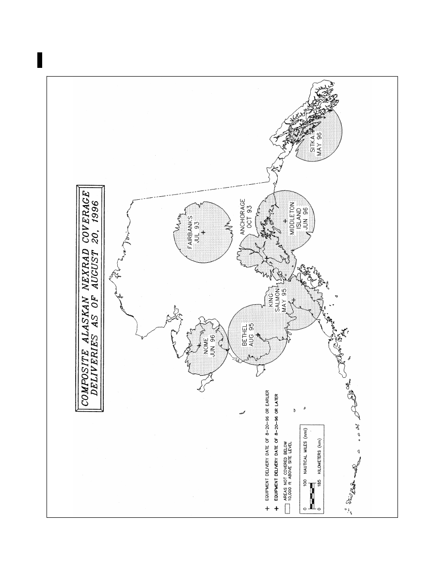
background image

AIM 

3/21/24 

d. 

All En Route Flight Advisory Service facilities and FSSs have equipment to directly access the radar 

displays from the individual weather radar sites. Specialists at these locations are trained to interpret the display 

for pilot briefing and inflight advisory services. The Center Weather Service Units located in ARTCCs also have 

access to weather radar displays and provide support to all air traffic facilities within their center’s area. 

e. 

For more detailed information on PIREPS, users can refer to the current version of the 

Aviation Weather 

Handbook

, FAA

H

8083

2

8

REFERENCE


Pilot/Controller Glossary Term


Precipitation Radar Weather Descriptions. 

AIM, Para 7

1

26, Thunderstorms. 

Chart Supplement, Charts, NWS Upper Air Observing Stations and Weather Network for the location of specific radar sites. 

7

1

12.  ATC Inflight Weather Avoidance Assistance 

a.  ATC Radar Weather Display. 

1. 

ATC radars are able to display areas of precipitation by sending out a beam of radio energy that is reflected 

back to the radar antenna when it strikes an object or moisture which may be in the form of rain drops, hail, or 

snow. The larger the object is, or the more dense its reflective surface, the stronger the return will be presented. 

Radar weather processors indicate the intensity of reflective returns in terms of decibels (dBZ). ATC systems 

cannot detect the presence or absence of clouds. The ATC systems can often determine the intensity of a 

precipitation area, but the specific character of that area (snow, rain, hail, VIRGA, etc.) cannot be determined. 

For this reason, ATC refers to all weather areas displayed on ATC radar scopes as “precipitation.” 

2. 

All ATC facilities using radar weather processors with the ability to determine precipitation intensity, will 

describe the intensity to pilots as: 

(a) 

“LIGHT”  (< 26 dBZ) 

(b) 

“MODERATE”  (26 to 40 dBZ) 

(c) 

“HEAVY”  (> 40 to 50 dBZ) 

(d) 

“EXTREME”  (> 50 dBZ) 

NOTE


En route ATC radar’s Weather and Radar Processor (WARP) does not display light precipitation intensity. 

3. 

ATC facilities that, due to equipment limitations, cannot display the intensity levels of precipitation, will 

describe the location of the precipitation area by geographic position, or position relative to the aircraft. Since 

the intensity level is not available, the controller will state “INTENSITY UNKNOWN.” 

4. 

ARTCC facilities normally use a Weather and Radar Processor (WARP) to display a mosaic of data 

obtained from multiple NEXRAD sites. There is a time delay between actual conditions and those displayed to 

the controller. For example, the precipitation data on the ARTCC controller’s display could be up to 6 minutes 

old. When the WARP is not available, a second system, the narrowband Air Route Surveillance Radar (ARSR) 

can display two distinct levels of precipitation intensity that will be described to pilots as “MODERATE” (30 

to 40 dBZ) and “HEAVY TO EXTREME” ( > 40 dBZ ). The WARP processor is only used in ARTCC facilities. 

5. 

ATC radar is not able to detect turbulence.

 Generally, turbulence can be expected to occur as the rate of 

rainfall or intensity of precipitation increases. Turbulence associated with greater rates of rainfall/precipitation 

will normally be more severe than any associated with lesser rates of rainfall/precipitation. Turbulence should 

be expected to occur near convective activity, even in clear air. Thunderstorms are a form of convective activity 

that imply severe or greater turbulence. Operation within 20 miles of thunderstorms should be approached with 

great caution, as the severity of turbulence can be markedly greater than the precipitation intensity might indicate. 

b.  Weather Avoidance Assistance. 

1. 

To the extent possible, controllers will issue pertinent information on weather or chaff areas and assist 

pilots in avoiding such areas when requested. Pilots should respond to a weather advisory by either 

7

1

40 

Meteorology