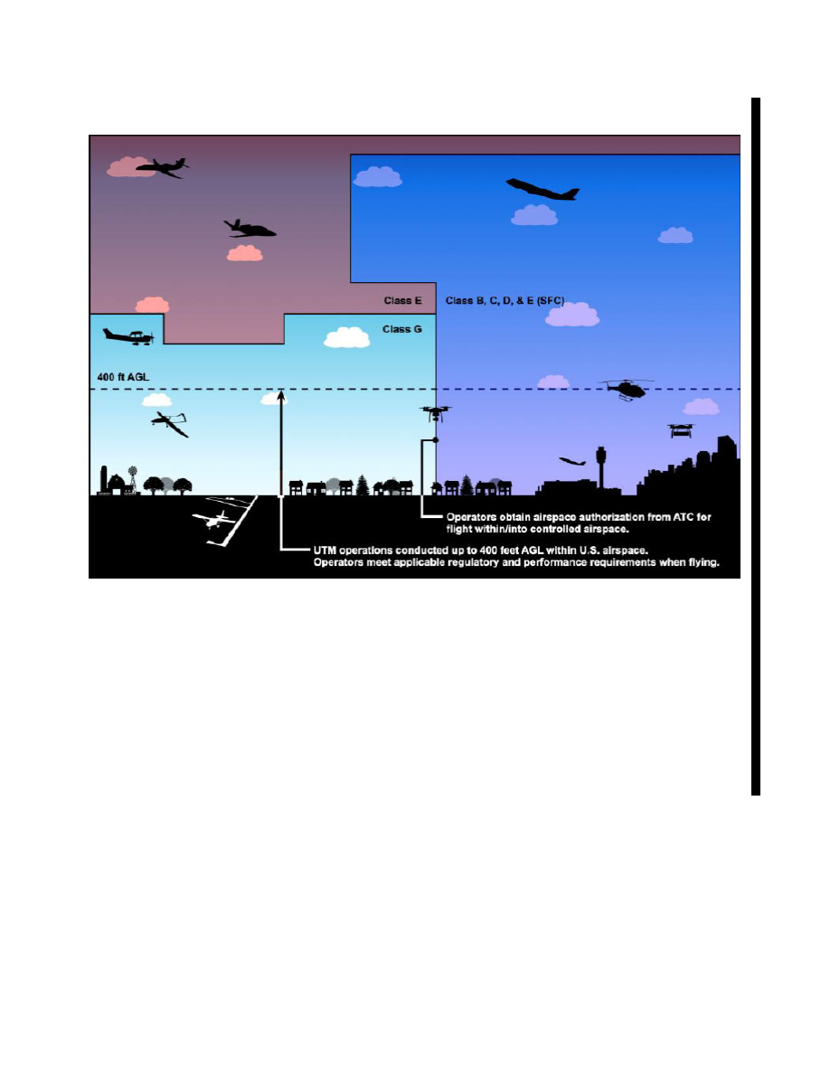
background image

5/19/22 

Pilot/Controller Glossary 

D

ATIS


(See DIGITAL-AUTOMATIC TERMINAL 

INFORMATION SERVICE.) 

D

ATIS [ICAO]


(See ICAO Term DATA LINK AUTOMATIC 

TERMINAL INFORMATION SERVICE.) 

DA [ICAO]


(See ICAO Term DECISION 

ALTITUDE/DECISION HEIGHT.) 

DAIR


(See DIRECT ALTITUDE AND IDENTITY 

READOUT.) 

DANGER AREA [ICAO]

 An airspace of defined 

dimensions within which activities dangerous to the 
flight of aircraft may exist at specified times. 

Note: The term “Danger Area” is not used in 

reference to areas within the United States or any 
of its possessions or territories. 

DAS


(See 

DELAY ASSIGNMENT

.) 

DATA BLOCK


(See ALPHANUMERIC DISPLAY.) 

DATA LINK AUTOMATIC TERMINAL INFOR-
MATION SERVICE (D

ATIS) [ICAO]

 The 

provision of ATIS via data link. 

DCT


(See DELAY COUNTDOWN TIMER.) 

DEAD RECKONING

 Dead reckoning, as applied 

to flying, is the navigation of an airplane solely by 
means of computations based on airspeed, course, 
heading, wind direction, and speed, groundspeed, 
and elapsed time. 

DEBRIS RESPONSE AREA (DRA)

 Used by ATC. 

Areas of airspace that may be activated in response to 
unplanned falling debris in the NAS. 

DECISION ALTITUDE/DECISION HEIGHT 
[ICAO Annex 6]- A specified altitude or height (A/H) 
in the precision approach at which a missed approach 
must be initiated if the required visual reference to 
continue the approach has not been established. 
1. Decision altitude (DA) is referenced to mean sea 

level and decision height (DH) is referenced to the 
threshold elevation. 
2. Category II and III minima are expressed as a DH 
and not a DA. Minima is assessed by reference to a 
radio altimeter and not a barometric altimeter, which 
makes the minima a DH. 
3. The required visual reference means that section of 
the visual aids or of the approach area which should 
have been in view for sufficient time for the pilot to 
have made an assessment of the aircraft position and 
rate of change of position, in relation to the desired 
flight path. 

DECISION ALTITUDE (DA)

 A specified altitude 

(mean sea level (MSL)) on an instrument approach 
procedure (ILS, GLS, vertically guided RNAV) at 
which the pilot must decide whether to continue the 
approach or initiate an immediate missed approach if 
the pilot does not see the required visual references. 

DECISION HEIGHT (DH)

 With respect to the 

operation of aircraft, means the height at which a 
decision must be made during an ILS or PAR 
instrument approach to either continue the approach 
or to execute a missed approach. 

(See ICAO term DECISION 

ALTITUDE/DECISION HEIGHT.) 

DECODER

 The device used to decipher signals 

received from ATCRBS transponders to effect their 
display as select codes. 

(See CODES.) 
(See RADAR.) 

DEFENSE AREA– Any airspace of the contiguous 
United States that is not an ADIZ in which the control 
of aircraft is required for reasons of national security. 

DEFENSE VISUAL FLIGHT RULES

 Rules 

applicable to flights within an ADIZ conducted under 
the visual flight rules in 14 CFR Part 91. 

(See AIR DEFENSE IDENTIFICATION ZONE.) 
(Refer to 14 CFR Part 91.) 
(Refer to 14 CFR Part 99.) 

DELAY ASSIGNMENT (DAS)

 Delays are distrib-

uted to aircraft based on the traffic management 
program parameters. The delay assignment is 
calculated in 15

minute increments and appears as a 

table in Traffic Flow Management System (TFMS)

PCG D