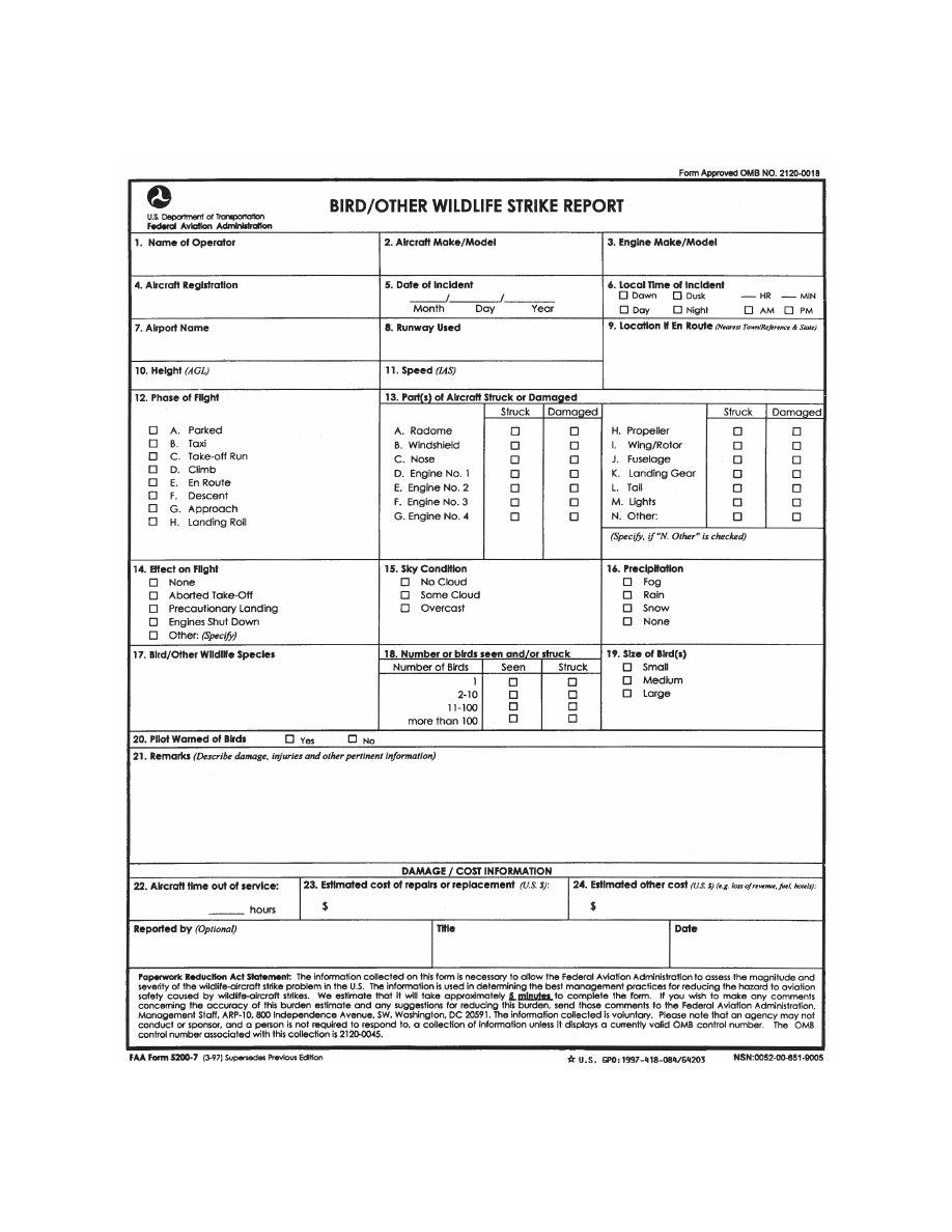
background image

6/17/21 

Pilot/Controller Glossary 

GATE HOLD PROCEDURES

 Procedures at 

selected airports to hold aircraft at the gate or other 
ground location whenever departure delays exceed or 
are anticipated to exceed 15 minutes. The sequence 
for departure will be maintained in accordance with 
initial call

up unless modified by flow control 

restrictions. Pilots should monitor the ground 
control/clearance delivery frequency for engine 
start/taxi advisories or new proposed start/taxi time 
if the delay changes. 

GCA


(See GROUND CONTROLLED APPROACH.) 

GDP


(See GROUND DELAY PROGRAM.) 

GENERAL AVIATION

 That portion of civil 

aviation that does not include scheduled or 
unscheduled air carriers or commercial space 
operations. 

(See ICAO term GENERAL AVIATION.) 

GENERAL AVIATION [ICAO]

 All civil aviation 

operations other than scheduled air services and 
nonscheduled air transport operations for remunera-
tion or hire. 

GEO MAP

 The digitized map markings associated 

with the ASR-9 Radar System. 

GLIDEPATH


(See GLIDESLOPE.) 

GLIDEPATH [ICAO]

 A descent profile determined 

for vertical guidance during a final approach. 

GLIDEPATH INTERCEPT ALTITUDE


(See GLIDESLOPE INTERCEPT ALTITUDE.) 

GLIDESLOPE

 Provides vertical guidance for 

aircraft during approach and landing. The glideslope/ 
glidepath is based on the following: 

a. 

Electronic components emitting signals which 

provide vertical guidance by reference to airborne 
instruments during instrument approaches such as 
ILS; or, 

b. 

Visual ground aids, such as VASI, which 

provide vertical guidance for a VFR approach or for 

the visual portion of an instrument approach and 
landing. 

c. 

PAR. Used by ATC to inform an aircraft making 

a PAR approach of its vertical position (elevation) 
relative to the descent profile. 

(See ICAO term GLIDEPATH.) 

GLIDESLOPE INTERCEPT ALTITUDE

 The 

published minimum altitude to intercept the 
glideslope in the intermediate segment of an 
instrument approach.  Government charts use the 
lightning bolt symbol to identify this intercept point. 
This intersection is called the Precise Final Approach 
fix (PFAF). ATC directs a higher altitude, the 
resultant intercept becomes the PFAF. 

(See FINAL APPROACH FIX.) 
(See SEGMENTS OF AN INSTRUMENT 

APPROACH PROCEDURE.) 

GLOBAL NAVIGATION SATELLITE SYSTEM 
(GNSS)

 GNSS refers collectively to the worldwide 

positioning, navigation, and timing determination 
capability available from one or more satellite 
constellations. A GNSS constellation may be 
augmented by ground stations and/or geostationary 
satellites to improve integrity and position accuracy. 

(See GROUND

BASED AUGMENTATION 

SYSTEM.) 

(See SATELLITE

BASED AUGMENTATION 

SYSTEM.) 

GLOBAL NAVIGATION SATELLITE SYSTEM 
MINIMUM EN ROUTE IFR ALTITUDE (GNSS 
MEA)

 The minimum en route IFR altitude on a 

published ATS route or route segment which assures 
acceptable Global Navigation Satellite System 
reception and meets obstacle clearance requirements. 
(Refer to 14 CFR Part 91.) 
(Refer to 14 CFR Part 95.) 

GLOBAL POSITIONING SYSTEM (GPS)

 GPS 

refers to the worldwide positioning, navigation and 
timing determination capability available from the 
U.S. satellite constellation.  The service provided by 
GPS for civil use is defined in the GPS Standard 
Positioning System Performance Standard. GPS is 
composed of space, control, and user elements. 

PCG G