875
Federal Aviation Administration, DOT
§ 95.17
latitude 42
°
26
′
N., longitude 79
°
13
′
W.; thence
to latitude 42
°
05
′
N., longitude 80
°
00
′
W.;
thence to latitude 40
°
50
′
N., longitude 80
°
00
′
W.; thence to latitude 40
°
26
′
N., longitude
79
°
54
′
W.; thence to latitude 38
°
25
′
N., lon-
gitude 81
°
46
′
W.; thence to latitude 36
°
00
′
N.,
longitude 86
°
00
′
W.; thence to latitude 33
°
37
′
N., longitude 86
°
45
′
W.; thence to latitude
32
°
30
′
N., longitude 86
°
25
′
W.; thence to lati-
tude 33
°
22
′
N., longitude 85
°
00
′
W.; thence to
latitude 36
°
35
′
N., longitude 79
°
20
′
W.; thence
to latitude 40
°
11
′
N., longitude 76
°
24
′
W.;
thence to latitude 41
°
24
′
N., longitude 74
°
30
′
W.; thence to latitude 41
°
43
′
N., longitude
72
°
40
′
W.; thence to latitude 42
°
13
′
N., lon-
gitude 72
°
44
′
W.; thence to latitude 43
°
12
′
N.,
longitude 71
°
30
′
W.; thence to latitude 43
°
45
′
N., longitude 70
°
30
′
W.; thence to latitude
45
°
00
′
N., longitude 69
°
30
′
W.; thence to lati-
tude 47
°
10
′
N., longitude 67
°
55
′
W., point of be-
ginning.
(b)
Exceptions. The area bounded by
the following coordinates:
Beginning at latitude 45
°
00
′
N., longitude
73
°
26
′
W.; thence to latitude 44
°
32
′
N., lon-
gitude 73
°
04
′
W.; thence to latitude 42
°
51
′
N.,
longitude 73
°
41
′
W.; thence to latitude 41
°
38
′
N., longitude 73
°
46
′
W.; thence to latitude
41
°
16
′
N., longitude 73
°
50
′
W.; thence to lati-
tude 41
°
17
′
N., longitude 74
°
00
′
W.; thence to
latitude 41
°
25
′
N., longitude 73
°
58
′
W.; thence
to latitude 41
°
26
′
N., longitude 74
°
01
′
W.;
thence to latitude 41
°
37
′
N., longitude 73
°
58
′
W.; thence to latitude 42
°
41
′
N., longitude
73
°
55
′
W.; thence to latitude 43
°
02
′
N., lon-
gitude 76
°
15
′
W.; thence to latitude 43
°
17
′
N.,
longitude 75
°
21
′
W.; thence to latitude 42
°
59
′
N., longitude 74
°
43
′
W.; thence to latitude
42
°
52
′
N., longitude 73
°
53
′
W.; thence to lati-
tude 44
°
30
′
N., longitude 73
°
18
′
W.; thence to
latitude 45
°
00
′
N., longitude 73
°
39
′
W.; thence
to latitude 45
°
00
′
N., longitude 73
°
26
′
W., point
of beginning.
[21 FR 2750, Apr. 28, 1956. Redesignated by
Amdt. 1–1, 28 FR 6718, June 29, 1963, as
amended at 73 FR 63885, Oct. 28, 2008]
§ 95.15
Western United States Moun-
tainous Area.
All of the following area excluding
that portion specified in the excep-
tions:
(a)
Area. From the Pacific coastline
of the United States, eastward along
the Canadian and Mexican borders, to
the following coordinates:
Beginning at latitude 49
°
00
′
N., longitude
108
°
00
′
W.; thence to latitude 46
°
45
′
N., lon-
gitude 104
°
00
′
W.; thence to latitude 44
°
06
′
N.,
longitude 103
°
15
′
W.; thence to latitude 43
°
00
′
N., longitude 103
°
15
′
W.; thence to latitude
41
°
52
′
N., longitude 103
°
39
′
W.; thence to lati-
tude 35
°
11
′
N., longitude 103
°
39
′
W.; thence to
latitude 33
°
17
′
N., longitude 104
°
27
′
W.; thence
to latitude 32
°
17
′
N., longitude 104
°
14
′
W.;
thence to latitude 29
°
48
′
N., longitude 102
°
00
′
W.
(b)
Exceptions.
(1) Beginning at latitude 35
°
25
′
N., lon-
gitude 119
°
09
′
W.; thence to latitude 35
°
29
′
N.,
longitude 118
°
58
′
W.; thence to latitude 36
°
49
′
N., longitude 119
°
37
′
W.; thence to latitude
38
°
30
′
N., longitude 121
°
24
′
W.; thence to lati-
tude 39
°
30
′
N., longitude 121
°
32
′
W.; thence to
latitude 40
°
08
′
N., longitude 122
°
08
′
W.; thence
to latitude 40
°
06
′
N., longitude 122
°
20
′
W.;
thence to latitude 39
°
05
′
N., longitude 122
°
12
′
W.; thence to latitude 38
°
01
′
N., longitude
121
°
51
′
W.; thence to latitude 37
°
37
′
N., lon-
gitude 121
°
12
′
W.; thence to latitude 37
°
00
′
N.,
longitude 120
°
58
′
W.; thence to latitude 36
°
14
′
N., longitude 120
°
11
′
W., point of beginning.
(2) Beginning at latitude 49
°
00
′
N., lon-
gitude 122
°
21
′
W.; thence to latitude 48
°
34
′
N.,
longitude 122
°
21
′
W.; thence to latitude 48
°
08
′
N., longitude 122
°
00
′
W.; thence to latitude
47
°
12
′
N., longitude 122
°
00
′
W.; thence to lati-
tude 46
°
59
′
N., longitude 122
°
13
′
W.; thence to
latitude 46
°
52
′
N., longitude 122
°
16
′
W.; thence
to latitude 46
°
50
′
N., longitude 122
°
40
′
W.;
thence to latitude 46
°
35
′
N., longitude 122
°
48
′
W.; thence to latitude 46
°
35
′
N., longitude
123
°
17
′
W.; thence to latitude 47
°
15
′
N., lon-
gitude 123
°
17
′
W.; thence to latitude 47
°
41
′
N.,
longitude 122
°
54
′
W.; thence to latitude 48
°
03
′
N., longitude 122
°
48
′
W.; thence to latitude
48
°
17
′
N., longitude 123
°
15
′
W.; thence North
and East along the United States and Canada
Boundary to latitude 49
°
00
′
N., longitude
122
°
21
′
W., point of beginning.
[21 FR 2750, Apr. 28, 1956. Redesignated by
Amdt. 1–1, 28 FR 6718, June 29, 1963, and
amended by Amdt. 95–255, 40 FR 2579, Jan. 14,
1975]
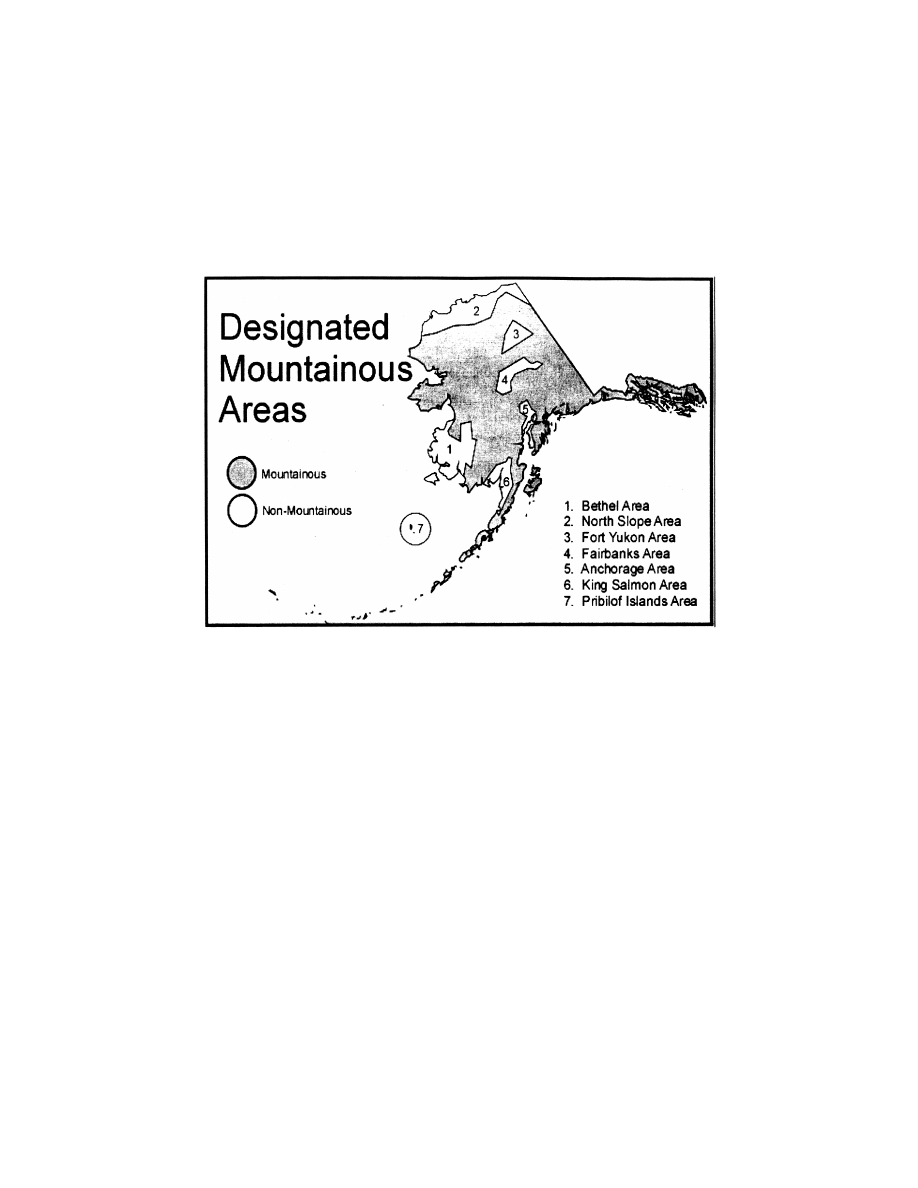
§ 95.17
Alaska Mountainous Area.
All of the following area excluding
those portions specified in the excep-
tions:
(a)
Area. The State of Alaska.
(b)
Exceptions;
(1)
Fairbanks—Nenana Area. Begin-
ning at latitude 64
°
54
′
N, longitude
147
°
00
′
W; thence to latitude 64
°
50
′
N,
longitude 151
°
22
′
W, thence to latitude
63
°
50
′
N, longitude 152
°
50
′
W; thence to
latitude 63
°
30
′
N, longitude 152
°
30
′
W;
thence to latitude 63
°
30
′
N, longitude
151
°
30
′
W; thence to latitude 64
°
05
′
N,
longitude 150
°
30
′
W; thence to latitude
64
°
20
′
N, longitude 149
°
00
′
W; thence to
latitude 64
°
07
′
N, longitude 146
°
30
′
W;
thence to latitude 63
°
53
′
N, longitude
146
°
00
′
W; thence to latitude 63
°
53
′
N,
longitude 145
°
00
′
W; thence to latitude
VerDate Sep<11>2014
14:00 Mar 14, 2024
Jkt 262047
PO 00000
Frm 00885
Fmt 8010
Sfmt 8002
Q:\14\14V2.TXT
PC31
aworley on LAPBH6H6L3 with DISTILLER