872
14 CFR Ch. I (1–1–24 Edition)
§ 93.353
(b) Pilots must fly along the west
shoreline of the Hudson River when
southbound, and along the east shore-
line of the Hudson River when north-
bound; while remaining within the
boundaries of the Hudson River Exclu-
sion as defined in § 93.350(d).
(c) Aircraft transiting the area with-
in the Hudson River Exclusion in ac-
cordance with § 93.350(b) must transit
the Hudson River Exclusion at or above
an altitude of 1,000 feet MSL up to, but
not including, the floor of the over-
lying Class B airspace.
§ 93.353
East River Exclusion specific
operating procedures.
No person may operate an airplane in
the East River Exclusion extending
from the southwestern tip of Governors
Island to the north tip of Roosevelt Is-
land except:
(a) Seaplanes landing on or taking off
from the river; or
(b) Airplanes authorized by ATC. Pi-
lots must contact LaGuardia Airport
Traffic Control Tower prior to Gov-
ernors Island for authorization.
PART 95—IFR ALTITUDES
S
PECIAL
F
EDERAL
A
VIATION
R
EGULATION
N
O
.
97 [N
OTE
]
Subpart A—General
Sec.
95.1
Applicability.
95.3
Symbols.
Subpart B—Designated Mountainous Areas
95.11
General.
95.13
Eastern United States Mountainous
Area.
95.15
Western United States Mountainous
Area.
95.17
Alaska Mountainous Area.
95.19
Hawaii Mountainous Area.
95.21
Puerto Rico Mountainous Area.
Subpart C—En Route IFR Altitudes Over
Particular Routes and Intersections
95.31
General.
Subpart D—Changeover Points
95.8001
General.
A
UTHORITY
: 49 U.S.C. 106(g), 40103, 40113,
and 14 CFR 11.49(b)(2).
S
PECIAL
F
EDERAL
A
VIATION
R
EGULATION
N
O
. 97
E
DITORIAL
N
OTE
: For the text of SFAR No.
97, see part 91 of this chapter.
Subpart A—General
§ 95.1
Applicability.
(a) This part prescribes altitudes gov-
erning the operation of aircraft under
IFR on ATS routes, or other direct
routes for which an MEA is designated
in this part. In addition, it designates
mountainous areas and changeover
points.
(b) The MAA is the highest altitude
on an ATS route, or other direct route
for which an MEA is designated, at
which adequate reception of VOR sig-
nals is assured.
(c) The MCA applies to the operation
of an aircraft proceeding to a higher
minimum en route altitude when cross-
ing specified fixes.
(d) The MEA is the minimum en
route IFR altitude on an ATS route,
ATS route segment, or other direct
route. The MEA applies to the entire
width of the ATS route, ATS route seg-
ment, or other direct route between
fixes defining that route. Unless other-
wise specified, an MEA prescribed for
an off airway route or route segment
applies to the airspace 4 nautical miles
on each side of a direct course between
the navigation fixes defining that route
or route segment.
(e) The MOCA assures obstruction
clearance on an ATS route, ATS route
segment, or other direct route, and
adequate reception of VOR navigation
signals within 22 nautical miles of a
VOR station used to define the route.
(f) The MRA applies to the operation
of an aircraft over an intersection de-
fined by ground-based navigation aids.
The MRA is the lowest altitude at
which the intersection can be deter-
mined using the ground-based naviga-
tion aids.
(g) The changeover point (COP) ap-
plies to operation of an aircraft along a
Federal airway, jet route, or other di-
rect route; for which an MEA is des-
ignated in this part. It is the point for
transfer of the airborne navigation ref-
erence from the ground-based naviga-
tion aid behind the aircraft to the next
VerDate Sep<11>2014
14:00 Mar 14, 2024
Jkt 262047
PO 00000
Frm 00882
Fmt 8010
Sfmt 8002
Q:\14\14V2.TXT
PC31
aworley on LAPBH6H6L3 with DISTILLER

873
Federal Aviation Administration, DOT
§ 95.13
appropriate ground-based navigation
aid to ensure continuous reception of
signals.
[Doc. No. FAA–2003–14698, 68 FR 16947, Apr. 8,
2003]
§ 95.3
Symbols.
For the purposes of this part—
(a)
COP means changeover point.
(b)
L means compass locator;
(c)
LF/MF means low frequency, me-
dium frequency;
(d)
LFR means low frequency radio
range;
(e)
VOR-E means VOR and distance
measuring equipment; and
(f)
Z means a very high frequency lo-
cation marker.
[Doc. No. 1580, 28 FR 6718, June 29, 1963, as
amended by Amdt. 95–118, 29 FR 13166, Sept.
23, 1964]
Subpart B—Designated
Mountainous Areas
§ 95.11
General.
The areas described in this subpart
are designated mountainous areas.
[Doc. No. 1580, 28 FR 6718, June 29, 1963]
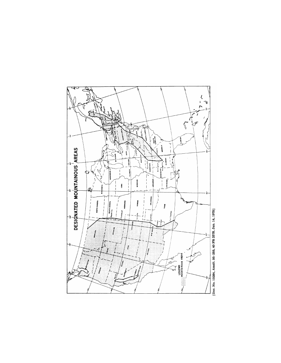
§ 95.13
Eastern United States Moun-
tainous Area.
All of the following area excluding
those portions specified in the excep-
tions.
(a)
Area.
VerDate Sep<11>2014
14:00 Mar 14, 2024
Jkt 262047
PO 00000
Frm 00883
Fmt 8010
Sfmt 8002
Q:\14\14V2.TXT
PC31
aworley on LAPBH6H6L3 with DISTILLER
874
14 CFR Ch. I (1–1–24 Edition)
§ 95.13
Beginning at latitude 47
°
10
′
N., longitude
67
°
55
′
W.; thence west and south along the
Canadian Border to latitude 45
°
00
′
N., lon-
gitude 74
°
15
′
W.; thence to latitude 44
°
20
′
N.,
longitude 75
°
30
′
W.; thence to latitude 43
°
05
′
N., longitude 75
°
30
′
W.; thence to latitude
42
°
57
′
N., longitude 77
°
30
′
W.; thence to lati-
tude 42
°
52
′
N., longitude 78
°
42
′
W.; thence to
VerDate Sep<11>2014
14:00 Mar 14, 2024
Jkt 262047
PO 00000
Frm 00884
Fmt 8010
Sfmt 8002
Q:\14\14V2.TXT
PC31
EC26SE91.005</GPH>
aworley on LAPBH6H6L3 with DISTILLER

875
Federal Aviation Administration, DOT
§ 95.17
latitude 42
°
26
′
N., longitude 79
°
13
′
W.; thence
to latitude 42
°
05
′
N., longitude 80
°
00
′
W.;
thence to latitude 40
°
50
′
N., longitude 80
°
00
′
W.; thence to latitude 40
°
26
′
N., longitude
79
°
54
′
W.; thence to latitude 38
°
25
′
N., lon-
gitude 81
°
46
′
W.; thence to latitude 36
°
00
′
N.,
longitude 86
°
00
′
W.; thence to latitude 33
°
37
′
N., longitude 86
°
45
′
W.; thence to latitude
32
°
30
′
N., longitude 86
°
25
′
W.; thence to lati-
tude 33
°
22
′
N., longitude 85
°
00
′
W.; thence to
latitude 36
°
35
′
N., longitude 79
°
20
′
W.; thence
to latitude 40
°
11
′
N., longitude 76
°
24
′
W.;
thence to latitude 41
°
24
′
N., longitude 74
°
30
′
W.; thence to latitude 41
°
43
′
N., longitude
72
°
40
′
W.; thence to latitude 42
°
13
′
N., lon-
gitude 72
°
44
′
W.; thence to latitude 43
°
12
′
N.,
longitude 71
°
30
′
W.; thence to latitude 43
°
45
′
N., longitude 70
°
30
′
W.; thence to latitude
45
°
00
′
N., longitude 69
°
30
′
W.; thence to lati-
tude 47
°
10
′
N., longitude 67
°
55
′
W., point of be-
ginning.
(b)
Exceptions. The area bounded by
the following coordinates:
Beginning at latitude 45
°
00
′
N., longitude
73
°
26
′
W.; thence to latitude 44
°
32
′
N., lon-
gitude 73
°
04
′
W.; thence to latitude 42
°
51
′
N.,
longitude 73
°
41
′
W.; thence to latitude 41
°
38
′
N., longitude 73
°
46
′
W.; thence to latitude
41
°
16
′
N., longitude 73
°
50
′
W.; thence to lati-
tude 41
°
17
′
N., longitude 74
°
00
′
W.; thence to
latitude 41
°
25
′
N., longitude 73
°
58
′
W.; thence
to latitude 41
°
26
′
N., longitude 74
°
01
′
W.;
thence to latitude 41
°
37
′
N., longitude 73
°
58
′
W.; thence to latitude 42
°
41
′
N., longitude
73
°
55
′
W.; thence to latitude 43
°
02
′
N., lon-
gitude 76
°
15
′
W.; thence to latitude 43
°
17
′
N.,
longitude 75
°
21
′
W.; thence to latitude 42
°
59
′
N., longitude 74
°
43
′
W.; thence to latitude
42
°
52
′
N., longitude 73
°
53
′
W.; thence to lati-
tude 44
°
30
′
N., longitude 73
°
18
′
W.; thence to
latitude 45
°
00
′
N., longitude 73
°
39
′
W.; thence
to latitude 45
°
00
′
N., longitude 73
°
26
′
W., point
of beginning.
[21 FR 2750, Apr. 28, 1956. Redesignated by
Amdt. 1–1, 28 FR 6718, June 29, 1963, as
amended at 73 FR 63885, Oct. 28, 2008]
§ 95.15
Western United States Moun-
tainous Area.
All of the following area excluding
that portion specified in the excep-
tions:
(a)
Area. From the Pacific coastline
of the United States, eastward along
the Canadian and Mexican borders, to
the following coordinates:
Beginning at latitude 49
°
00
′
N., longitude
108
°
00
′
W.; thence to latitude 46
°
45
′
N., lon-
gitude 104
°
00
′
W.; thence to latitude 44
°
06
′
N.,
longitude 103
°
15
′
W.; thence to latitude 43
°
00
′
N., longitude 103
°
15
′
W.; thence to latitude
41
°
52
′
N., longitude 103
°
39
′
W.; thence to lati-
tude 35
°
11
′
N., longitude 103
°
39
′
W.; thence to
latitude 33
°
17
′
N., longitude 104
°
27
′
W.; thence
to latitude 32
°
17
′
N., longitude 104
°
14
′
W.;
thence to latitude 29
°
48
′
N., longitude 102
°
00
′
W.
(b)
Exceptions.
(1) Beginning at latitude 35
°
25
′
N., lon-
gitude 119
°
09
′
W.; thence to latitude 35
°
29
′
N.,
longitude 118
°
58
′
W.; thence to latitude 36
°
49
′
N., longitude 119
°
37
′
W.; thence to latitude
38
°
30
′
N., longitude 121
°
24
′
W.; thence to lati-
tude 39
°
30
′
N., longitude 121
°
32
′
W.; thence to
latitude 40
°
08
′
N., longitude 122
°
08
′
W.; thence
to latitude 40
°
06
′
N., longitude 122
°
20
′
W.;
thence to latitude 39
°
05
′
N., longitude 122
°
12
′
W.; thence to latitude 38
°
01
′
N., longitude
121
°
51
′
W.; thence to latitude 37
°
37
′
N., lon-
gitude 121
°
12
′
W.; thence to latitude 37
°
00
′
N.,
longitude 120
°
58
′
W.; thence to latitude 36
°
14
′
N., longitude 120
°
11
′
W., point of beginning.
(2) Beginning at latitude 49
°
00
′
N., lon-
gitude 122
°
21
′
W.; thence to latitude 48
°
34
′
N.,
longitude 122
°
21
′
W.; thence to latitude 48
°
08
′
N., longitude 122
°
00
′
W.; thence to latitude
47
°
12
′
N., longitude 122
°
00
′
W.; thence to lati-
tude 46
°
59
′
N., longitude 122
°
13
′
W.; thence to
latitude 46
°
52
′
N., longitude 122
°
16
′
W.; thence
to latitude 46
°
50
′
N., longitude 122
°
40
′
W.;
thence to latitude 46
°
35
′
N., longitude 122
°
48
′
W.; thence to latitude 46
°
35
′
N., longitude
123
°
17
′
W.; thence to latitude 47
°
15
′
N., lon-
gitude 123
°
17
′
W.; thence to latitude 47
°
41
′
N.,
longitude 122
°
54
′
W.; thence to latitude 48
°
03
′
N., longitude 122
°
48
′
W.; thence to latitude
48
°
17
′
N., longitude 123
°
15
′
W.; thence North
and East along the United States and Canada
Boundary to latitude 49
°
00
′
N., longitude
122
°
21
′
W., point of beginning.
[21 FR 2750, Apr. 28, 1956. Redesignated by
Amdt. 1–1, 28 FR 6718, June 29, 1963, and
amended by Amdt. 95–255, 40 FR 2579, Jan. 14,
1975]
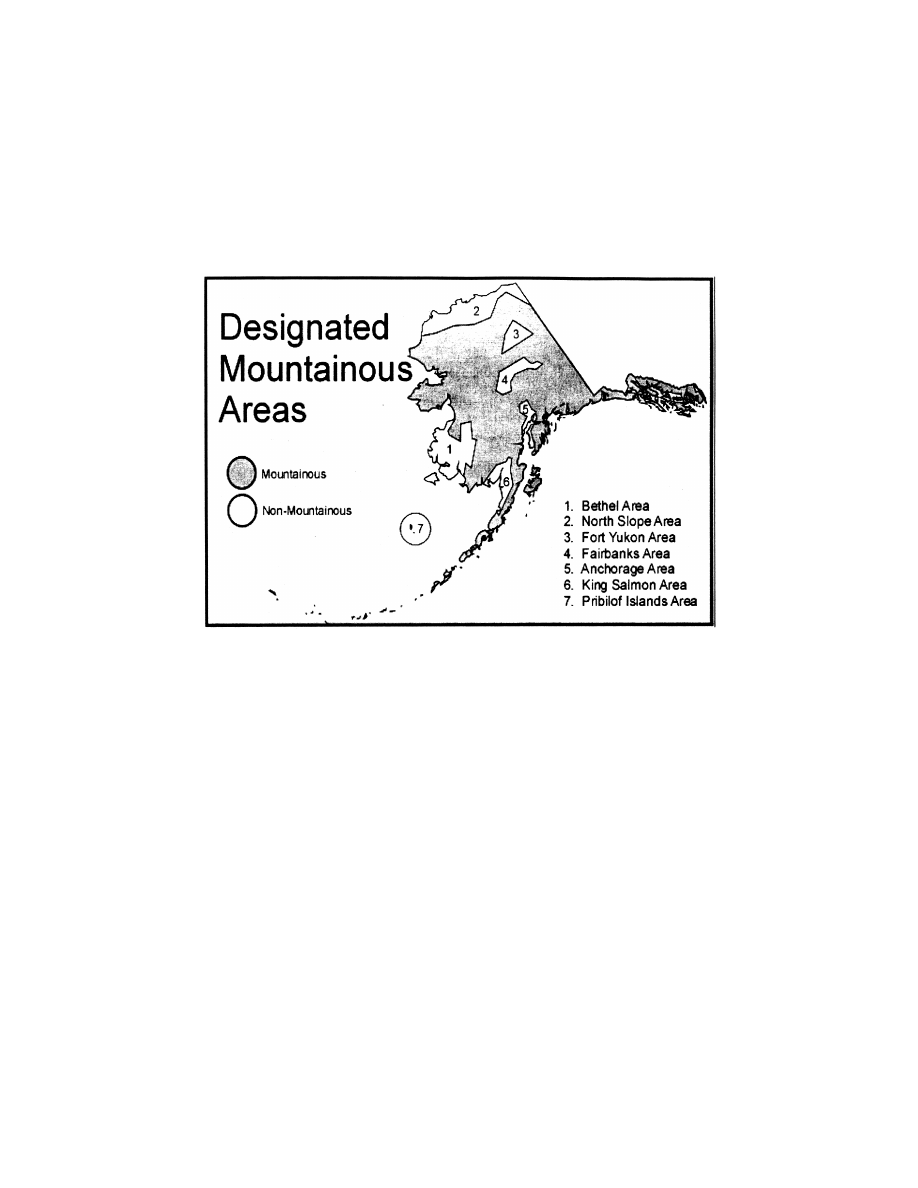
§ 95.17
Alaska Mountainous Area.
All of the following area excluding
those portions specified in the excep-
tions:
(a)
Area. The State of Alaska.
(b)
Exceptions;
(1)
Fairbanks—Nenana Area. Begin-
ning at latitude 64
°
54
′
N, longitude
147
°
00
′
W; thence to latitude 64
°
50
′
N,
longitude 151
°
22
′
W, thence to latitude
63
°
50
′
N, longitude 152
°
50
′
W; thence to
latitude 63
°
30
′
N, longitude 152
°
30
′
W;
thence to latitude 63
°
30
′
N, longitude
151
°
30
′
W; thence to latitude 64
°
05
′
N,
longitude 150
°
30
′
W; thence to latitude
64
°
20
′
N, longitude 149
°
00
′
W; thence to
latitude 64
°
07
′
N, longitude 146
°
30
′
W;
thence to latitude 63
°
53
′
N, longitude
146
°
00
′
W; thence to latitude 63
°
53
′
N,
longitude 145
°
00
′
W; thence to latitude
VerDate Sep<11>2014
14:00 Mar 14, 2024
Jkt 262047
PO 00000
Frm 00885
Fmt 8010
Sfmt 8002
Q:\14\14V2.TXT
PC31
aworley on LAPBH6H6L3 with DISTILLER

876
14 CFR Ch. I (1–1–24 Edition)
§ 95.17
64
°
09
′
N, longitude 145
°
16
′
W; thence to
latitude 64
°
12
′
N, longitude 146
°
00
′
W;
thence to latitude 64
°
25
′
N, longitude
146
°
37
′
W; thence to latitude 64
°
54
′
N,
longitude 147
°
00
′
W, point of beginning.
(2)
Anchorage—Homer Area. Beginning
at latitude 61
°
50
′
N, longitude 151
°
12
′
W;
thence to latitude 61
°
24
′
N, longitude
150
°
28
′
W; thence to latitude 61
°
08
′
N,
longitude 151
°
47
′
W; thence to latitude
59
°
49
′
N, longitude 152
°
40
′
W; thence to
latitude 59
°
25
′
N, longitude 153
°
10
′
W;
thence to latitude 59
°
00
′
N, longitude
153
°
10
′
W; thence to latitude 59
°
33
′
N,
longitude 151
°
28
′
W; thence to latitude
60
°
31
′
N, longitude 150
°
43
′
W; thence to
latitude 61
°
13
′
N, longitude 149
°
39
′
W;
thence to latitude 61
°
37
′
N, longitude
149
°
15
′
W; thence to latitude 61
°
44
′
N,
longitude 149
°
48
′
W; thence to latitude
62
°
23
′
N, longitude 149
°
54
′
W; thence to
latitude 62
°
23
′
N, longitude 150
°
14
′
W;
thence to latitude 61
°
50
′
N, longitude
151
°
12
′
W, point of beginning.
(3)
King Salmon—Port Heiden Area. Be-
ginning at latitude 58
°
49
′
N, longitude
159
°
30
′
W; thence to latitude 59
°
40
′
N,
longitude 157
°
00
′
W; thence to latitude
59
°
40
′
N, longitude 155
°
30
′
W; thence to
latitude 59
°
50
′
N, longitude 154
°
50
′
W;
thence to latitude 59
°
35
′
N, longitude
154
°
40
′
W; thence to latitude 58
°
57
′
N,
longitude 156
°
05
′
W; thence to latitude
58
°
00
′
N, longitude 156
°
20
′
W; thence to
latitude 57
°
00
′
N, longitude 158
°
20
′
W;
thence to latitude 56
°
43
′
N, longitude
158
°
39
′
W; thence to latitude 56
°
27
′
N,
longitude 160
°
00
′
W; thence along the
shoreline to latitude 58
°
49
′
N, longitude
159
°
30
′
W, point of beginning.
(4)
Bethel—Aniak Area. Beginning at
latitude 63
°
28
′
N, longitude 161
°
30
′
W;
thence to latitude 62
°
40
′
N, longitude
163
°
03
′
W; thence to latitude 62
°
05
′
N,
longitude 162
°
38
′
W; thence to latitude
61
°
51
′
N, longitude 160
°
43
′
W; thence to
latitude 62
°
55
′
N, longitude 160
°
30
′
W;
thence to latitude 63
°
00
′
N, longitude
158
°
00
′
W; thence to latitude 61
°
45
′
N,
longitude 159
°
30
′
W; thence to latitude
61
°
34
′
N, longitude 159
°
15
′
W; thence to
latitude 61
°
07
′
N, longitude 160
°
20
′
W;
thence to latitude 60
°
25
′
N, longitude
160
°
40
′
W; thence to latitude 59
°
36
′
N,
longitude 161
°
49
′
W; thence along the
shoreline to latitude 63
°
28
′
N, longitude
161
°
30
′
W; point of beginning; and
Nunivak Island.
(5)
North Slope Area. Beginning at a
point where latitude 69
°
30
′
N intersects
the northwest coast of Alaska and
eastward along the 69
°
30
′
parallel to
latitude 69
°
30
′
N, longitude 156
°
00
′
W;
thence to latitude 69
°
10
′
N, longitude
153
°
00
′
W; thence eastward along the
69
°
10
′
N parallel to latitude 69
°
10
′
N,
longitude 149
°
00
′
W; thence to latitude
69
°
50
′
N, longitude 146
°
00
′
W; thence
eastward along the 69
°
50
′
N parallel to
latitude 69
°
50
′
N, longitude 145
°
00
′
W;
thence to latitude 69
°
35
′
N, longitude
141
°
00
′
W; thence northward along the
141
°
00
′
W Meridian to a point where the
141
°
00
′
W Meridian intersects the north-
east coastline of Alaska; thence west-
ward along the northern coastline of
Alaska to the intersection of latitude
69
°
30
′
N; point of beginning .
(6)
Fort Yukon Area. Beginning at
latitude 67
°
20
′
N, longitude 144
°
00
′
W;
thence to latitude 66
°
00
′
N, longitude
143
°
00
′
W; thence to latitude 66
°
05
′
N,
longitude 149
°
00
′
W; thence to latitude
66
°
45
′
N, longitude 148
°
00
′
W; thence to
latitude 67
°
00
′
N, longitude 147
°
00
′
W;
thence to latitude 67
°
20
′
N, longitude
144
°
00
′
W; point of beginning.
(7) The islands of Saint Paul and
Saint George, together known as the
Pribilof Islands, in the Bering Sea.
VerDate Sep<11>2014
14:00 Mar 14, 2024
Jkt 262047
PO 00000
Frm 00886
Fmt 8010
Sfmt 8002
Q:\14\14V2.TXT
PC31
aworley on LAPBH6H6L3 with DISTILLER
877
Federal Aviation Administration, DOT
§ 95.17
[Doc. No. FAA–2004–19352, 70 FR 7360, Feb. 11, 2005]
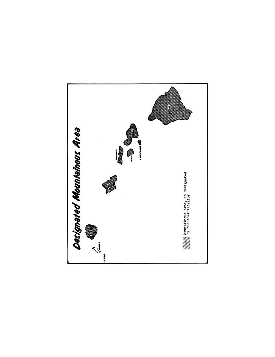
§ 95.19
Hawaii Mountainous Area.
The following islands of the State of Hawaii: Kauai, Oahu, Molokai, Lanai,
Kehoolawe, Maui, and Hawaii.
VerDate Sep<11>2014
14:00 Mar 14, 2024
Jkt 262047
PO 00000
Frm 00887
Fmt 8010
Sfmt 8026
Q:\14\14V2.TXT
PC31
ER11FE05.004</GPH>
aworley on LAPBH6H6L3 with DISTILLER
878
14 CFR Ch. I (1–1–24 Edition)
§ 95.21
[Amdt. 88, 27 FR 4536, May 8, 1962. Redesignated by Amdt. 1–1, 28 FR 6719, June 29, 1963]
§ 95.21
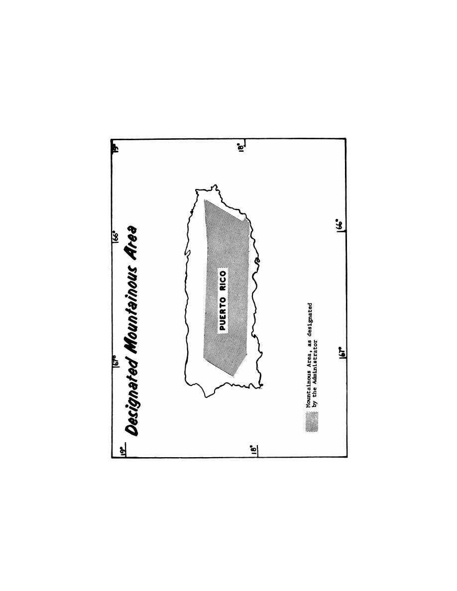
Puerto Rico Mountainous Area.
The area bounded by the following
coordinates:
Beginning at latitude 18
°
22
′
N., longitude
66
°
58
′
W., thence to latitude 18
°
19
′
N., lon-
gitude 66
°
06
′
W.; thence to latitude 18
°
20
′
N.,
longitude 65
°
50
′
W.; thence to latitude 18
°
20
′
N., longitude 65
°
42
′
W.; thence to latitude
18
°
03
′
N., longitude 65
°
52
′
W.; thence to lati-
tude 18
°
02
′
N., longitude 65
°
51
′
W.; thence to
latitude 17
°
59
′
N., longitude 65
°
55
′
W.; thence
to latitude 18
°
05
′
N., longitude 66
°
57
′
W.;
thence to latitude 18
°
11
′
N., longitude 67
°
07
′
W.; thence to latitude 18
°
22
′
N., longitude
66
°
58
′
W.; the point of beginning.
VerDate Sep<11>2014
14:00 Mar 14, 2024
Jkt 262047
PO 00000
Frm 00888
Fmt 8010
Sfmt 8002
Q:\14\14V2.TXT
PC31
EC26SE91.007</GPH>
aworley on LAPBH6H6L3 with DISTILLER
879
Federal Aviation Administration, DOT
§ 95.21
[Amdt. 88, 27 FR 4536, May 8, 1962; 27 FR 5603, June 13, 1962. Redesignated by Amdt. 1–1, 28
FR 6719, June 29, 1963]
VerDate Sep<11>2014
14:00 Mar 14, 2024
Jkt 262047
PO 00000
Frm 00889
Fmt 8010
Sfmt 8026
Q:\14\14V2.TXT
PC31
EC26SE91.008</GPH>
aworley on LAPBH6H6L3 with DISTILLER

880
14 CFR Ch. I (1–1–24 Edition)
§ 95.31
Subpart C—En Route IFR Altitudes
Over Particular Routes and
Intersections
E
DITORIAL
N
OTE
: The prescribed IFR alti-
tudes for flights over particular routes and
intersections in this subpart were formerly
carried as §§ 610.11 through 610.6887 of this
title and were transferred to part 95 as
§§ 95.41 through 95.6887, respectively, but are
not carried in the Code of Federal Regula-
tions. For F
EDERAL
R
EGISTER
citations af-
fecting these routes, see the List of CFR Sec-
tions Affected, which appears in the Finding
Aids section of the printed volume and at
www.govinfo.gov.
§ 95.31
General.
This subpart prescribes IFR altitudes
for flights along particular routes or
route segments and over additional
intersections not listed as a part of a
route or route segment.
[Doc. No. 1580, 28 FR 6719, June 29, 1963]
Subpart D—Changeover Points
E
DITORIAL
N
OTE
: The prescribed COP’s for
Federal airways, jet routes, or other direct
routes for which an MEA is designated in
this part are not carried in the Code of Fed-
eral Regulations. For F
EDERAL
R
EGISTER
ci-
tations affecting these routes see the List of
CFR Sections Affected, which appears in the
Finding Aids section of the printed volume
and at
www.govinfo.gov.
§ 95.8001
General.
This subpart prescribes COP’s for
Federal airways, jet routes, area navi-
gation routes, or other direct routes
for which an MEA is designated in this
part. Unless otherwise specified the
COP is midway between the navigation
facilities or way points for straight
route segments, or at the intersection
of radials or courses forming a dogleg
in the case of dogleg route segments.
[Doc. No. 10580, 35 FR 14610, Sept. 18, 1970]
PART 97—STANDARD INSTRUMENT
PROCEDURES
Subpart A—General
Sec.
97.1
Applicability.
97.3
Symbols and terms used in procedures.
97.5
Bearings, courses, tracks, headings,
radials, miles.
Subpart B—Procedures
97.10
[Reserved]
Subpart C—TERPS Procedures
97.20
General.
A
UTHORITY
: 49 U.S.C. 106(f), 106(g), 40103,
40106, 40113, 40114, 40120, 44502, 44514, 44701,
44719, and 44721–44722.
S
OURCE
: Docket No. 1580, 28 FR 6719, June
29, 1963, unless otherwise noted.
Subpart A—General
§ 97.1
Applicability.
(a) This part prescribes standard in-
strument approach procedures to civil
airports in the United States and the
weather minimums that apply to land-
ings under IFR at those airports.
(b) This part also prescribes obstacle
departure procedures (ODPs) for cer-
tain civil airports in the United States
and the weather minimums that apply
to takeoffs under IFR at civil airports
in the United States.
[Doc. No. FAA–2002–14002, 72 FR 31679, June 7,
2007]
§ 97.3
Symbols and terms used in pro-
cedures.
As used in the standard instrument
procedures prescribed in this part—
Aircraft approach category means a
grouping of aircraft based on a speed of
VREF, if specified, or if VREF is not
specified, 1.3 V
so
at the maximum cer-
tificated landing weight. VREF, V
so
,
and the maximum certificated landing
weight are those values as established
for the aircraft by the certification au-
thority of the country of registry. The
categories are as follows—
(1) Category A: Speed less than 91
knots.
(2) Category B: Speed 91 knots or
more but less than 121 knots.
(3) Category C: Speed 121 knots or
more but less than 141 knots.
(4) Category D: Speed 141 knots or
more but less than 166 knots.
(5) Category E: Speed 166 knots or
more.
Approach procedure segments for which
altitudes (minimum altitudes, unless
otherwise specified) and paths are pre-
scribed in procedures, are as follows—
VerDate Sep<11>2014
14:00 Mar 14, 2024
Jkt 262047
PO 00000
Frm 00890
Fmt 8010
Sfmt 8010
Q:\14\14V2.TXT
PC31
aworley on LAPBH6H6L3 with DISTILLER