AIM
4/20/23
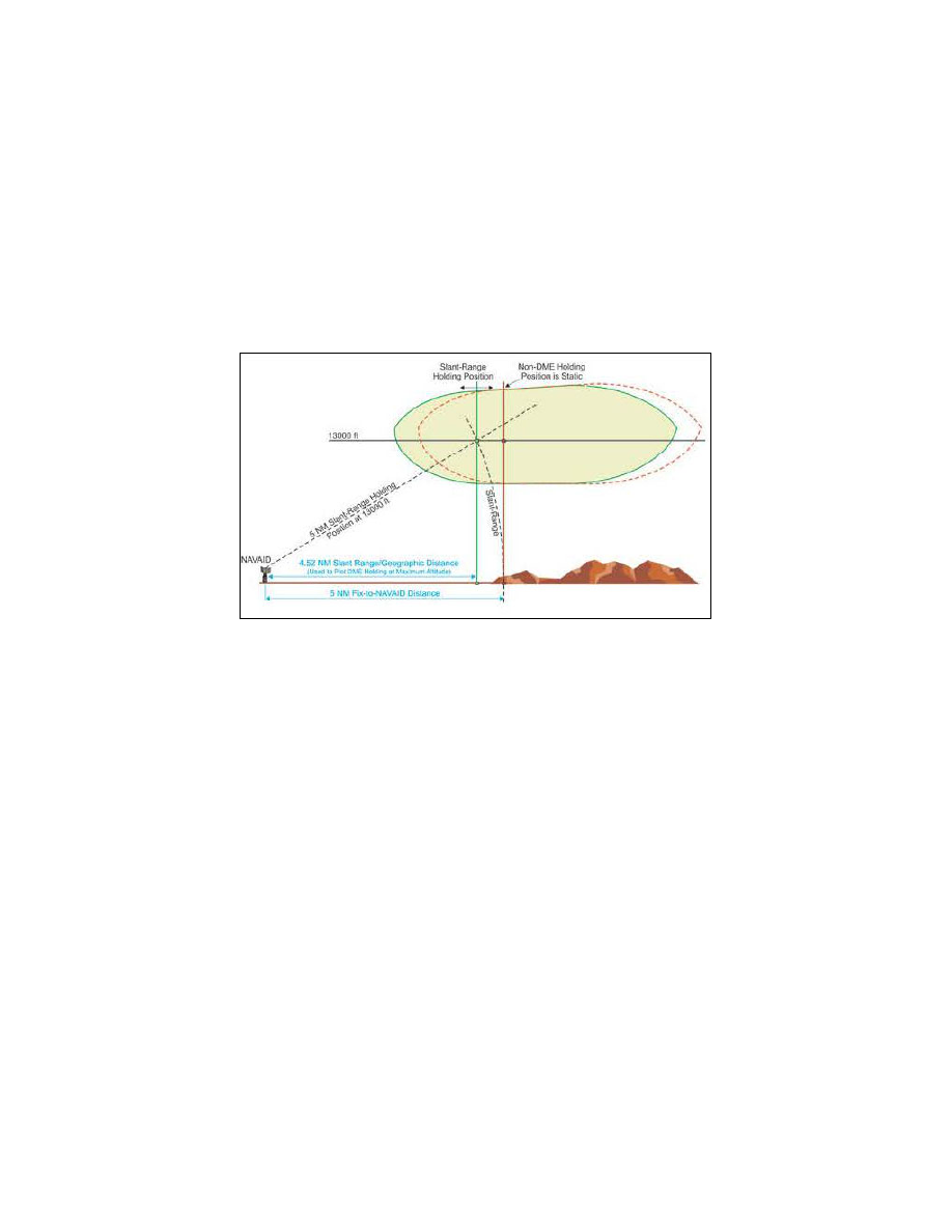
6. Use of RNAV Distance in lieu of DME Distance.
Substitution of RNAV computed distance to or from
a NAVAID in place of DME distance is permitted when holding. However, the actual holding location and pattern
flown will be further from the NAVAID than designed due to the lack of slant range in the position solution (see
7). This may result in a slight difference between RNAV distance readout in reference to the NAVAID
and the DME readout, especially at higher altitudes. When used solely for DME substitution, the difference
between RNAV distance to/from a fix and DME slant range distance can be considered negligible and no pilot
action is required.
REFERENCE
−
AIM, Para 1
3, Use of Suitable Area Navigation (RNAV) Systems on Conventional Procedures and Routes.
FIG 5
−
3
−
7
Difference Between DME Distance From NAVAID & RNAV Computed Distance From NAVAID
7. Use of RNAV Guidance and Holding.
RNAV systems, including multi
−
sensor Flight Management
Systems (FMS) and stand
−
alone GPS receivers, may be used to furnish lateral guidance when executing a hold.
The manner in which holding is implemented in an RNAV system varies widely between aircraft and RNAV
system manufacturers. Holding pattern data may be extracted from the RNAV database for published holds or
may be manually entered for ad
−
hoc ATC
−
assigned holds. Pilots are expected to be familiar with the capabilities
and limitations of the specific RNAV system used for holding.
(a)
All holding, including holding defined on an RNAV or RNP procedure, is based on the conventional
NAVAID holding design criteria, including the holding protected airspace construction. There are differences
between the holding entry and flight track assumed in conventional holding pattern design and the entry and track
that may be flown when RNAV guidance is used to execute holding. Individually, these differences may not affect
the ability of the aircraft to remain within holding pattern protected airspace. However, cumulatively, they can
result in deviations sufficient to result in excursions up to limits of the holding pattern protected airspace, and
in some circumstances beyond protected airspace. The following difference and considerations apply when an
RNAV system furnishes the lateral guidance used to fly a holding pattern:
(1)
Many systems use ground track angle instead of heading to select the entry method. While the
holding pattern design allows a 5 degree tolerance, this may result in an unexpected entry when the winds induce
a large drift angle.
(2)
The holding protected airspace is based on the assumption that the aircraft will fly
−
over the holding
fix upon initial entry. RNAV systems may execute a “fly
−
by” turn when approaching the holding fix prior to
entry. A “fly
−
by” turn during a direct entry from the holding pattern side of holding course may result in
excursions beyond protected airspace, especially as the intercept angle and ground speed increase.
(3)
During holding, RNAV systems furnish lateral steering guidance using either a constant bank or
constant radius to achieve the desired inbound and outbound turns. An aircraft’s flight guidance system may use
En Route Procedures
5
−
3
−
26