AIM
4/20/23
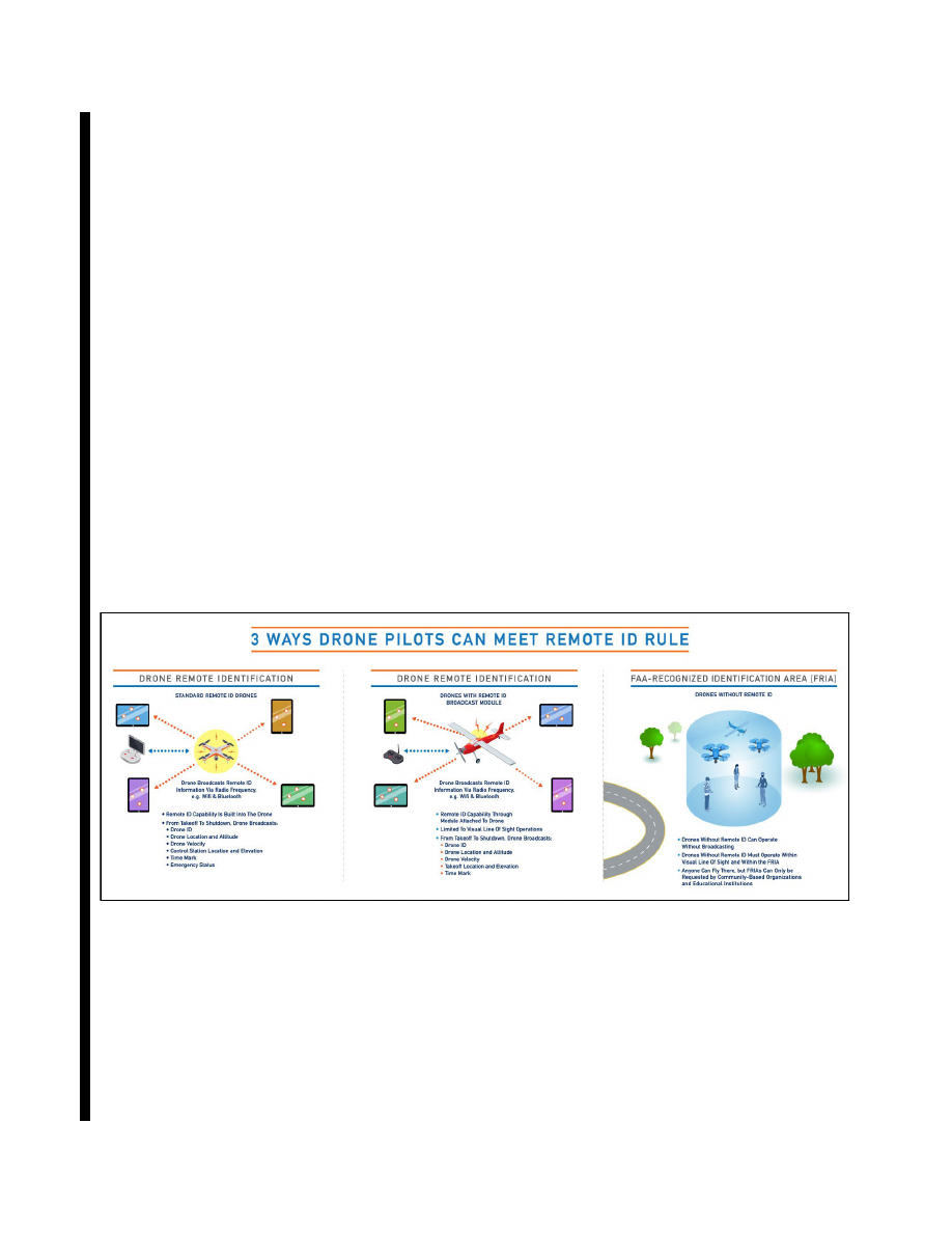
indication of the control station latitude, longitude, and geometric altitude; (4) a time mark; and (5) an emergency
status indication. Operators may choose whether to use the serial number of the unmanned aircraft or a session
ID (e.g., an alternative form of identification that provides additional privacy to the operator) as the unique
identifier.
(b)
RID Broadcast Modules. An unmanned aircraft can be equipped with a Remote ID broadcast module
that broadcasts message elements from takeoff to shutdown. Message elements include: (1) The serial number
of the broadcast module assigned by the producer; (2) an indication of the latitude, longitude, geometric altitude,
and velocity of the unmanned aircraft; (3) an indication of the latitude, longitude, and geometric altitude of the
unmanned aircraft takeoff location; and (4) a time mark.
(c)
FAA
−
Recognized Identification Area:
(1)
An FAA
−
recognized identification area (FRIA) is a defined geographic area where persons can
operate UAS without remote identification, provided they maintain visual line of sight. Organizations eligible
to request establishment of a FRIA include CBOs recognized by the FAA and educational institutions. The latter
group includes primary and secondary educational institutions, trade schools, colleges, and universities.
(2)
To operate in a FRIA according to the 14 CFR Part 89, RID of unmanned aircraft, operators must
be physically located within the boundaries of the FRIA, must only operate drones within those boundaries, and
must operate within VLOS at all times. UAS equipped with RID broadcast capability must broadcast
continuously even while operating within or transiting a FRIA.
REFERENCE
−
14 CFR Part 89, Remote Identification of Unmanned Aircraft
.
(3)
1 illustrates the three ways UAS operators can comply with the new RID rule.
FIG 11
−
4
−
1
RID Paths to Compliance
11
−
4
−
5. Airspace Access for 14 CFR Part 135 and 14 CFR Part 137
a.
14 CFR Part 135, Operating Requirements: Commuter and on Demand Operations and Rules Governing
Persons on Board Such Aircraft:
1.
Civil operators of UAS may conduct commercial package delivery BVLOS, or may transport HAZMAT
on an interstate basis (crossing state boundaries), only under 14 CFR Part 135. These types of operations are
prohibited for UAS operating under 14 CFR Part 107, sUAS. Legally, these operations must be conducted under
14 CFR Part 91, UAS operations, in accordance with an air carrier certificate issued under 14 CFR Part 135, and
an exemption from certain federal aviation regulations granted under 14 CFR Part 11, general rulemaking
procedures.
11
−
4
−
4
Airspace Access for UAS